In our data-driven world, understanding spatial relationships is no longer just for geographers or urban planners. Whether you are tracking the spread of a wildfire, optimizing a delivery route, or analyzing urban growth, you are likely relying on Geographic Information Systems (GIS). But what exactly makes this system work? To truly grasp its power, we need to look beyond the maps and examine the core architecture that supports them.
Before diving into the technical layers, it is essential to understand the foundation. If you are new to this field, you might ask, what is GIS technology? Essentially, it is a framework for gathering, managing, and analyzing data rooted in the science of geography. By integrating many types of data, it allows us to visualize patterns and relationships that are otherwise invisible.
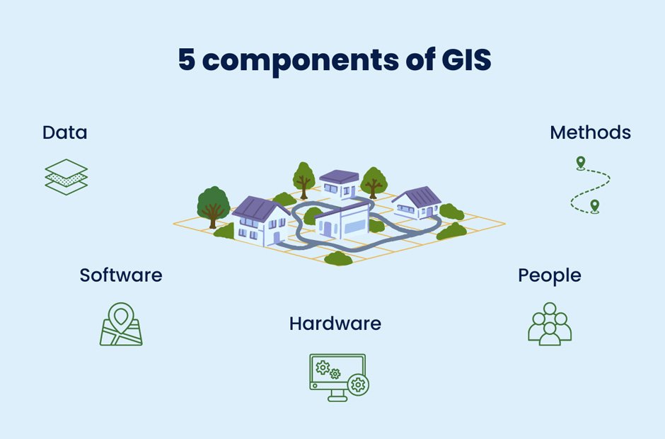
In this article, we will break down the components of GIS to see how they work together to turn raw data into actionable intelligence.
1. Hardware: The Physical Engine
Hardware is the physical backbone of any GIS operation. In the past, this meant high-end workstations and bulky servers. Today, the landscape has shifted significantly.
GIS hardware now ranges from:
- High-Performance Computers: Necessary for complex spatial modeling and processing large datasets.
- Mobile Devices: Smartphones and tablets used by field researchers to collect GPS-tagged data in real-time.
- Cloud Servers: Allowing for remote processing and collaborative mapping across the globe.
- Drones and Satellites: Acting as the “eyes in the sky” to capture high-resolution imagery.
![Image Placeholder: A high-tech workstation showing a complex 3D topographical map on multiple monitors]
2. Software: The Toolkit
Software provides the tools and functions needed to store, analyze, and display geographic information. There are two main categories of GIS software:
- Commercial Software: Platforms like Esri’s ArcGIS offer comprehensive, professional-grade tools for enterprise-level analysis.
- Open Source Software: QGIS is a popular choice for those who need a flexible, community-driven platform without licensing costs.
The software component is responsible for handling the “heavy lifting,” such as database management, map creation, and performing spatial queries (e.g., “How many houses are within 5 miles of the flood zone?”).
3. Data: The Most Critical Component
Without data, a GIS is just an empty shell. In fact, data is often the most expensive and time-consuming part of any GIS project. There are two primary types of data used:
- Vector Data: Uses points, lines, and polygons to represent discrete features like street lights, roads, and lake boundaries.
- Raster Data: Uses a grid of cells (pixels) to represent continuous data, such as satellite imagery or elevation models.
Modern GIS systems also incorporate Attribute Data, which provides additional information about a location. For example, a point on a map might represent a building, but the attribute data tells you the building’s age, height, and current owner.
![Image Placeholder: A split-screen graphic showing the difference between Vector (points/lines) and Raster (pixels/grid) data]
4. People: The Brains Behind the Map
While technology is impressive, it is the people who define the “why” and “how” of a project. The components of GIS are only effective when managed by skilled professionals. These include:
- GIS Managers: Who oversee projects and budgets.
- GIS Analysts: Who interpret the data and perform spatial modeling.
- Technicians: Who focus on data entry and map production.
- End Users: The people who use the final maps or apps to make decisions, such as a city mayor or a logistics coordinator.
Human intuition is required to ask the right questions and ensure that the analysis is ethically sound and accurately reflects reality.
5. Methods: The Framework for Success
Methods (or procedures) are the business rules and operating practices unique to each organization. A successful GIS operates according to a well-designed plan. This includes:
- Data Standards: Ensuring that data collected by different teams can be integrated seamlessly.
- Analysis Workflows: Step-by-step processes for converting raw data into a final report.
- Maintenance Schedules: Keeping datasets updated so that decisions are based on the most current information.
![Image Placeholder: A flow-chart diagram showing a standard GIS workflow from data collection to final analysis output]
The Synergy of the Components
It is important to remember that these five components do not exist in isolation. They are interdependent. If your hardware is outdated, your software will lag. If your data is inaccurate, your methods will produce flawed results. Conversely, when all five components are optimized, GIS becomes a revolutionary tool for solving some of the world’s most complex problems—from climate change mitigation to urban infrastructure development.
Conclusion
Understanding the components of GIS provides a roadmap for anyone looking to leverage spatial data. By balancing hardware, software, data, people, and methods, organizations can unlock insights that lead to smarter, more sustainable decisions.
Whether you are a student, a business owner, or a curious learner, realizing that GIS is a holistic system—rather than just a “mapping tool”—is the first step toward mastering the geography of the future.